 The Avenues is Salt Lake City’s largest historic district, comprising a grand locality of approximately 100 square blocks of late 19th and early 20th century residential, commercial, and civic architecture in a variety of styles. Developed primarily between 1860 and 1930, the Avenues comprises structures built along tree-lined streets that are arranged on a sloping north-south, east-west grid. For over a century, the neighborhood has existed as a thriving, evolving community with a unique historic character.
Salt Lake City was founded in 1847. By the 1850s, rapid growth in industry, crafts, trades, and manufacturing occurred, and with this expansion Salt Lake City shifted from a village to a metropolis. During this transitional stage, the Avenues district of Salt Lake City was established, primarily for artisans, tradesmen, common laborers, and others who desired to live in close proximity to the urban city center. The Avenues, laid out as Plat D of Salt Lake City, was the first section of the municipality to deviate from the original city plan of 10-acre blocks patterned after the “Plat of the City Zion” provided by Joseph Smith, the founder and prophet of the Church of Jesus Christ of Latter-Day Saints.
 Likely a consequence of the steep slopes and the lack of water on the “Dry Bench” geography of the district, the smaller streets and blocks of the Avenues resulted in a dense building pattern and streetscape considerably different from the rest of the city. The differences became even more pronounced when lots were subdivided by their original owners, sometimes with houses so close together that roof-lines touched and side yards became non-existent.
The variation from the original city plat is also reflected in the street names. Originally the north-south streets were named for trees – such as Walnut, Chestnut, and Pine – and the original, four east-west avenues were named Fruit, Garden, Bluff and Wall Streets. By 1885, the east-west streets had become 1st, 2nd, 3rd, and 4th Streets; and the north-south streets had been lettered from A to V (later Virginia) Streets. In 1907, perhaps to avoid confusion with the street names below South Temple, the City Commission voted to change the numbered Streets to Avenues. This area presents the only use of lettered streets in Utah.
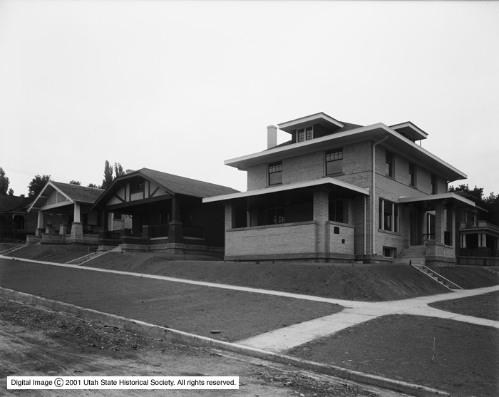
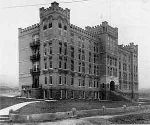
 Improved transit, along with the expanded water supply to the Avenues after 1900, accelerated the construction of homes in the neighborhood at the turn of the 20th century. Though most of the homes built around 1900 were simpler in their presentation, exhibiting the standardized “pattern book” designs made popular by developers such as the Modern Home Building Company and the National Real Estate and Investment Company, over 100 architect-designed homes have been identified in the Avenues Historic District. These homes were built in styles including Queen Anne, Prairie, Craftsman, Mediterranean, Spanish Colonial Revival, Victorian, Tudor, and Art Moderne.
Some of the state's finest examples of residential architectural styles were built here, including:
- The William Barton house, 231 B Street (Vernacular/Gothic)
- The Jeremiah Beattie house, 30 J Street (Eastlake)
- The David Murdock house, 73 G Street (Queen Anne)
- The N.H. Beeman house, 1007 First Avenue (Shingle)
- The William McIntyre house, 257 Seventh Avenue (Classical Revival)
- The James Sharp house, 157 D Street (Craftsman)
 These structures are a significant element of the district’s visual character, which is unique in its integration of architectural varieties. Despite the visual variety in the Avenues, a number of factors are responsible for creating an aspect of aesthetic continuity in the district: similar setbacks, clustered styles, roof pitches, front porches, retaining walls, fences, landscaping, and duplication of the same house type along one street.
The mixed character of the Avenues population in the late 19th and early 20th centuries reflected the changing character of Salt Lake City. With the increased influence of the mining industry in Utah and improved rail transportation, as well as a general expansion of industrial activity, emphasis shifted from the city's previous agricultural prominence. The area functioned primarily as a middle-class suburb for the city’s downtown commercial district. In its development, religious and local government officials, artisans, merchants, mining entrepreneurs, educators, physicians, attorneys, and laborers all combined to make the Avenues a diverse section of Salt Lake City, and therefore boasted a variety of residential, civic, and service-related enterprises.
Churches and schools were built in the area to meet the needs of residents. The LDS Church maintained four wards, and Catholic residents worshipped at the Cathedral of the Madeleine on B Street and South Temple. Several schools were constructed, including the Longfellow School (corner of J Street and 1st Avenue) and Lowell School (E Street and 2nd Avenue). The Groves-LDS Hospital (8th Avenue between C and D Streets) was built to serve the entire city, and many hospital personnel lived in the Avenues.
 Important Utah families, including the Lyons, Romneys, Hansens, Claytons, Brains, Grants, Glades, and Wells have maintained strong ties in the Avenues, with properties often remaining in family possession for many generations. After the turn of the 20th century, fashionable neighborhoods were developed to the east and south of the Avenues, around the new campus of the University of Utah, and the number of very large residences built on the Avenues declined. In the southwest corner of the Avenues Historic District, which borders the edge of City Creek Canyon and the central business district, a number of larger apartment buildings were constructed. They document the 20th century trend in the Avenues toward rental properties, both in the conversion of single-family houses and the construction of new apartment buildings.
By the 1960s, an increasingly transient population combined with the growth of absentee ownership led to a gradual deterioration of the area. However, in recent years the Avenues has experienced revitalization as new and old residents alike have joined to seek the regeneration of old residences and preservation of the visual and architectural elements that characterize the area. The GACC was organized as an advocacy group attempting to preserve the lifestyle of one of Salt Lake City's most historically significant residential areas, and the group has been instrumental in the preparation of the Avenues Master Plan and a number of downzoning efforts.
The Avenues Historic District was listed on the National Register of Historic Places in 1978, and continues to exist as a safe and beautiful community of friendly, involved neighbors.
See the Avenues Master Plan, developed in 1987 HERE
References
- Anderson, Charles Brooks. “The Growth Pattern of Salt Lake City, and Its Determining Factors.” Ph.D. Dissertation, New York University, 1945.
- Anderson, Mary J. “Interpersonal Relationships in a Salt Lake City Neighborhood, Part I: Lower Avenues.” M.A. Thesis, University of Utah, 1964.
- Avenues Survey, Structure/Site Information Forms. Preservation Office, Utah State Historical Society, 1978-79.
- Cooper II, Wallace N., “Historic District Design Guidelines,” and “Report on the Avenues”, prepared for the Utah State Historical Society Preservation Office, 1979.
- Goss, Peter L. “The Architectural History of Utah.” Utah Historical Quarterly, 43:3 (Summer 1975), 206-239.
- Harris, Kip King. “Return to the City: A Study of Architectural Restoration/Renovation in the Context of the Avenues District of Salt Lake City.” M.Arch. Thesis, University of Utah, 1978.
- McCormick, John. “A History of the Avenues.” Unpublished Report, Utah State Historical Society, 1978.
- Wright, Paul A. “The Growth and Distribution of Mormon and Non-Mormon Population in Salt Lake City.” M.A. Thesis, the University of Chicago, 1970.
Other Resources
- Karl Haglund, Architectural Historian, and Philip F. Notarianni, Preservation Historian, Utah State Historical Society, Avenues Historic District, Salt Lake City, Salt Lake County, UT, nomination document, 1979, National Park Service, National Register of Historic Places, Washington, D.C.
- Pioneer Map Plat D and Empire Mill Tract, Great Salt Lake City. Nicholas G. Morgan Collection, Utah State Historical Society, Map #538.
- Portions of this content were adapted from a copy of the original nomination document. Adaptation copyright © 2011, The Gombach Group
- Salt Lake City Historic Preservation – Local Historic Districts